Mapping the Value of Watershed Services
More and more cities are coming to realize that they can slash water treatment costs by investing in the maintenance of distant forests and valleys – thereby laying the foundation for a more sustainable water strategy by improving the forest’s ability to capture, store, and filter rainwater. New tools are helping them maximize their investments by identifying the most environmentally valuable pieces of forestland.
More and more cities are coming to realize that they can slash water treatment costs by investing in the maintenance of distant forests and valleys – thereby laying the foundation for a more sustainable water strategy by improving the forest’s ability to capture, store, and filter rainwater. New tools are helping them maximize their investments by identifying the most environmentally valuable pieces of forestland.
24 January 2011 | Cities around the world envy – and emulate – New York City for the way it keeps its water clean. Rather than paying billions to filter out gunk, the city pays farmers upstream in the Catskills to maintain the forests that feed the mountain streams that fill its reservoirs.
When NYC signed a memorandum of understanding with upstate communities and NGOs in the Catskill and Delaware watersheds, the city’s comptroller requested a comprehensive scientific review by the National Research Council of the National Academies.
Paul Barten served on the review committee, and says the team quickly realized that forestland was being prioritized on the basis of parcel size (a minimum of 50 acres) rather than its potential influence on streamflow and water quality. Watershed managers and the land acquisition staff members were under pressure to protect as much land as possible and that sometimes resulted in passing over small, yet critical, valley bottom (riparian) sites in favor of larger parcels at substantial distances from streams.
The more economically-valuable land tends to be gently-sloped and well-drained, says Barten – but land that has the greatest impact on water quality is “forest land with steep slopes, immediately adjacent to streams with silt or clay soils that are frequently saturated.”
A professor of Forest Resources at the University of Massachusetts in Amherst, Barten knew there had to be a better way.
The Conservation Priority Index
Barten teamed up with a UMass-Amherst grad student of his, Yanli Zhang, now an assistant professor at Stephen F. Austin University in Texas, to develop the Conservation Priority Index (CPI). Craig Nicolson and William VanDoren, also at UMass-Amherst, have worked with Barten to improve the CPI scoring techniques, using part of the Portland, Maine, water supply as the prototype.
The CPI is one of many tools available today providing decision-makers with helpful data, highlighting the most environmentally-valuable land when it comes to PWS schemes.
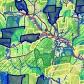
Based on Geographic Information Systems (GIS), the CPI rates forestland parcels according to several characteristics, including land use; distance to streams and wetlands; depth to water table; permeability; slope; and whether it is located directly between streams and roads.
More information about the CPI can be found in additional documents under “Prioritizing Land to Protect Water.”
The result is a ranking of land parcels based on conservation value — and not on size and price. In this system, a parcel of 10 acres can be ranked higher than a parcel of 100 acres if it filters more water. From this information, decision makers — regardless of their occupation — can easily understand which parcels are the most essential for water quality.
When the analysis is complete, “We have confidence that we are looking at parcels that really matter for water supply protection,” says Barten.
Why Forests?
Cities are growing, and private development is threatening essential watersheds – often because administrators and citizens are unaware of a critical link between healthy forests and clean water.
“Forest land is the most protective land use,” says Al Todd, Assistant Director of Ecosystems and Markets for the US Forest Service.
“In contrast with developed areas, forests are remarkably efficient, low maintenance, solar-powered living filters,” writes Barten in the essay, Why Forests Provide the Best Protection for Water Resources.
“Forests serve as a living sponge to capture, store, and slowly release precipitation as well as trapping and transforming the chemicals and nutrient deposits that come in the rain or from adjacent runoff,” say Todd and Emily Weidner in their article “Valuing Drinking Water as an Ecosystem Service.”
“The future security of water supplies will not be ensured by water treatment alone,” says the US Forest Service’s (USFS) State and Private Forestry organization in Forests, Water and People: Drinking water supply and forest lands in the Northeast and Midwest United States . “Protecting and managing forests in source watersheds is an essential part of future strategies for providing clean, safe, and affordable drinking water.” In other words, investing in the green rather than the grey infrastructure.
In Late August, Denver listened to this advice and followed in New York City’s footsteps by enacting a Payment for Watershed Services (PWS) scheme. Denver Water, a utility company, struck a $33 Million deal with the U.S. Forest Service, dedicating a portion of the city’s water fees to the protection and restoration of forests in the area.
Conservation may sound expensive, but doing nothing to protect forests can cost even more. If forests are allowed to erode and development continues to soil fresh ground water, the costs could be astronomical.
“The only option will be to build advanced water supply technology,” says Barten, “Right now, you can pay a modest fee for conservation.”
Connecting to the Source
It’s not always easy to gain support for these PWS schemes because urban populations do not always make the connection between the source and their clean drinking water. But the CPI can help them make that vital connection.
“With this tool, we are drawing basic connections between drinking water and the land from which it flows,” says Todd.
To clearly illustrate their efforts, U-Mass Amherst and the US Forest Service teamed up to form the self-descriptive Forest-to Faucet Partnership.
Changing People’s Approach
To further develop the CPI and to encourage communities to critically analyze their watershed management programs, the Forest-to-Faucet partnership joined with the Trust for Public Land to carry out the Source Water Stewardship Project. The project was developed in response to an EPA “Request for Proposals.”
To help determine the locations for the project’s case studies, the team utilized the “Forest, Water and People” analysis report, which was spearheaded by a USFS team and included recently completed map analysis of watersheds in the Northeast and Southeast regions of the US.
The analysis, which looks mainly at the scale of 150,000-acre watersheds, highlights watersheds that the greatest number of people rely on for drinking water and therefore are most likely to feel the strain of over development. These basic maps can include a number of other details.
“They can be overlaid with threats of urban development, fire, serious forest health problems and vulnerability induced by climate change,” says Todd.
Finally, the maps can identify which land is privately-owned and could, therefore, be under threat for development in the future, according to Kelley Hart, Conservation Vision Associate Director at Trust for Public Land. This is essential information, especially for forest land in the Eastern United States, and one of the reasons the mapping began there.
“In the Eastern United States, private individuals own 70% of forest,” says Barten. With the regional maps, the Source Water Stewardship Project team could determine where this posed the largest threat to water quality.
The four different watersheds chosen were located in Georgia; New Hampshire and Massachusetts; Maryland and Pennsylvania; and New Jersey. The watersheds represented “a wide range of biophysical and sociopolitical characteristics.”
The first step of each case study was the establishment of local steering committees. Local stakeholders—including non-profits, water utility companies and individual activists—met with members of the partnership and evaluated watershed management.
“We needed to know the most sensitive areas for water quality,” says Todd. “Then we could prioritize the landscape.”
This is where the CPI came in. It was utilized to help determine conservation and management priorities for forest land. Then experts in the field were brought in to speak to the steering committees about how to approach these priorities. “We developed a protection strategy with the communities,” says Todd.
All of the case studies produced positive changes regarding the area’s water source management, according to Barten. But Georgia provides the best illustration.
In a suburb west of Atlanta, residents who relied on the Little Tallapoosa River Watershed decided they needed to make a dramatic change. Because they wanted to deter an increase in water-borne diseases as well as the current speed of development in their county, 62% of the residents voted in favor of a $20 million per year tax bond to support the conservation and restoration of 30 to 40,000 acres of forest.
Expanding the Analysis
The Forest Service has expanded the “Forest, Water and People” analysis, completing watershed assessment maps of the entire United States. “It is a tool to sort out the national landscape,” says Todd; it helps the Forest Service make decisions about priorities and future opportunities involving watershed management.
As the project proposal describes, “the project will use maps and statistics to describe the relative importance of private forests and National Forest System lands to surface drinking water supplies across the United States.”
“We needed to know the most sensitive areas in the watershed for water quality so that we could prioritize the landscape,” says Todd.
For Barten, these regional maps help “identify where the story needs to be told.” When they have been identified, regional maps can be overlaid with CPI-type analysis.
“This analysis focuses on the grand scale,” says Barten; “it identifies where forest loss would have the greatest impact.”
The Lower Meramec River Watershed
When the Forest Service expressed interest in partnering with TPL for another Source Water Demonstration Project, these expanded regional maps helped the team choose a location. The project, which began in 2008, was an effort to build on the success of the case studies, according to Hart. For the project, the partnership looked for a threatened watershed that supplied a great number of people.
The Lower Meramec River Watershed in the St. Louis, Missouri region was one of these top-priority watersheds, according to Hart; it became the focus of the project. GSI mapping and CPI analysis re-emphasized the need to focus on these lands, according to Barten. From the data, “We know it’s even more important,” he says.
The watershed provides over 200,000 people with clean drinking water, but many of those that benefitted did not know that the river was the source of their drinking water. In other words, they did not understand that pollution or damage in the Meramec would have a direct impact on their drinking water.
Though this was a high-priority area in terms of watershed management, the Forest Service and TPL needed support on the ground before the project began. “We needed to understand the capacity at the local level to be our partners,” says Hart. Potential partners would have to be interested in watershed management and be willing to raise the funds for implementation. And they were. “It looked like a great place to work,” adds Hart.
The Boeing Company Charitable Foundation made a contribution to TPL for this project. In addition, the Open Space Council and the East-West Gateway Council of Governments raised funds for the project and increased local awareness. These groups as well as the Missouri DNR volunteered to be part of the project long-term. These groups determined that CPI analysis best fit their community’s needs.
The last step before work began was the establishment of a steering committee. The Meramec River Tributary Alliance (MRTA), a pre-existing but newly established group of stakeholders, became this committee. According to Hart, they were the source of local preliminary maps and data.
“We asked them ‘What kind of problems could we tackle?’” says Hart. The answers helped the team hone in on a more specific area of the watershed.
Then the project partners, including the MRTA, attended a 5-day Strategy Exchange. Essentially, the exchange consisted of a series of workshops in which experts discussed specific issues, including river pollution and the possibility of approaching land owners about easements to help protect water quality. These meetings helped determine the next steps, including application of the CPI to determine essential forest land parcels.
Through the MRTA, sub-committees were formed to handle each topic discussed at the Strategy Exchange. These sub-committees developed strategies based on the workshop’s expert recommendation. This project, just like the case studies, is producing positive results in terms of watershed management.
“There are a whole lot of other benefits besides clean water” says Barten, “The conservation protects fisheries, recreation and wildlife. Protecting the water also has a cultural value in St. Louis.”
As David Wilson, a member of the East-West Gateway Council of Governments, says in reflecting on the project , “This initiative represents a tremendous opportunity for the St. Louis region to develop a long term strategy to protect the Meramec River and drinking water for several hundred thousand people…With many local, state and federal initiatives already under way, and many non-profit organizations putting resources into specific efforts at water quality protection, we have embraced this opportunity to prioritize areas for collaboration.”
More information and the maps involved in the project can be found in the related links section.
Goals for the Future
Barten hopes that the use of the CPI in water source stewardship will continue to expand.
The final goal is to make the software accessible for anyone interested in carrying out analysis on their own. UMass-Amherst will possibly develop distance learning to encourage individuals “to take a shot at it,” says Barten, “We want to convince them that they can do it on their own.”
Additional resources
Please see our Reprint Guidelines for details on republishing our articles.