Kenyan Cattlemen Map Watershed Services
Ranchers understand the importance of watershed services as well as anyone and better than most, which is why the Nairobi-based International Livestock Research Institute decided to map watershed services in the arid and semi-arid lands that cover approximately 80% of Kenya.
Ranchers understand the importance of watershed services as well as anyone and better than most, which is why the Nairobi-based International Livestock Research Institute decided to map watershed services in the arid and semi-arid lands that cover approximately 80% of Kenya.
21 December 2011 | NAIROBI | Kenya | Iconic savanna plains carry the vision and spirit of romance depicted in Karen Blixen’s Out of Africa. The snaking lines of wildebeests, large herds of elephants, lions roaring in the distance, and brilliant sunsets as the Maasai warrior walks in the distance while herding his cows to the nearest water hole.
That nearest water hole or water body is the bane of existence of this savanna ecosystem. Everything depends on it. When the rains roll in, green grass attracts wildebeests to the savanna plains, which then lure in the large predators. The pastoral communities also follow the rains in search of fodder for their cows, their main source of livelihood.
Changes on the Ground
Life in these landscapes ebb and flow with water, but it is not until a catastrophe strikes that we realize that water is the basis of life. In the recent past, extreme climatic events such as droughts and floods have highlighted the vulnerability of this natural wonder of the world to the impacts of climate change.
The pastoral communities who have in the past lived harmoniously with the wildlife have begun to settle down and alternatively practice agriculture for food security as cattle populations have been decimated in long dry periods, land degradation due to poor land use practices has ensued, wildlife has been constrained into smaller areas as human population has expanded creating human-wildlife conflict, and the resilience of the ecosystem to extreme climatic events has begun to vanish.
Changes in the Air
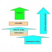
As climate change increases the frequency and intensity of floods and droughts in these ecosystems, water catchment and management becomes a crucial tool in building ecosystems resilience. For practical water management, entire watersheds need to considered; from the water catchment in highland forests to the basins in the lowlands.
Understanding the dynamics of the watershed, conducting cost-benefit analysis of different land use practices, and determining the economic value of ecosystem services in particular water, forests and biodiversity plays a key role in advocating for conservation and sustainable development of landscapes, where linkages between ecosystem services and human well-being are well documented.
Cattlemen Need to Know
That’s why the International Livestock Research Institute (ILRI), a Nairobi-based NGO, published Mapping and Valuing Ecosystem Services in the Ewaso Ng’iro Watershed to inform the Government of Kenya on the latest developments on arid and semi-arid lands (ASAL’s) that cover approximately 80% of the country.
Typically, ASAL’s encompass a range between the savanna grasslands and desert areas. The extent of the Ewaso Ng’iro North watershed, the subject of the study, begins in the highlands of Mount Kenya where agriculture, logging and land grabbing have been documented, to the lower plains of Laikipia and Samburu which are famous for the wildlife and rich culture.
The Technology
The step-by-step approach of mapping and valuing the ecosystem services of the watershed began with using spatial imagery to map the extent and characteristics of the watershed. This included water, biomass, livestock, wildlife and irrigated crops. These services were quantified and the demand for these services based on different land-use systems measured. An economic valuation of these services was then conducted.
The results of such a study are expected to inform the Government of Kenya on how to improve the standard of living in the region. This tool allows for a comparison of “alternative land and water uses between livestock, crop production, and wildlife-based tourism to enable future assessments of how and how much each use will improve the standard of living and whose standard of living.”
Determining the ecosystem services of the watershed takes into account more criteria than just water, but the categorization of water makes it possible to determine it’s unique value to human well-being.
Measuring the Outputs
The ILRI study priced the value of water based on what production systems water was a main contributor too, namely crop and livestock. It showed that value of water requirements for crops was much higher than livestock in the drylands, a cost that can now be used as a tool for various water pricing schemes and conservation incentives by policy makers.
The study also indirectly priced water’s contribution to tourism and biomass, values that can be used to compare different land use implications.
The use of such a study is not limited to policy implementation, but can inform a range of conservation and development initiatives on where to focus effort.
Considering different land use implications, energies can be directed towards opportunities that can deliver maximum benefit at least cost. This could be by developing conservation areas where agriculture may not be viable, or developing market mechanisms to boost livestock production. Payments for ecosystem services can also be developed for such watersheds to advocate for their conservation.
Water is at the centre of the web of life. Valuing it is complex. When we talk about ecosystem services we look at the impact of ecosystems on human well-being. So what about water’s contribution to health, recreation, construction, aesthetics? Should it be limited to just water? How do we price it so that it makes sense? Where do we draw the line on the benefits? And how do we make sure of information accuracy when large databases are required for such studies? Water is becoming a common buzz word in a world where global warming, rural development and population growth are determining factors. It is vital, it is complicated, but studies such as the one conducted by ILRI take the first steps in informing us the how’s, why’s, what’s and how much ecosystems contribute to human well-being.
Additional resources
Please see our Reprint Guidelines for details on republishing our articles.